Sunday, January 31, 2021

Bend Ranch State Park - part 1

On Saturday I left Paint Gap 1, took a slight 6 mile detour to the Panther Junction Visitor Center to dump trash and refill water, then headed west out of the National Park and to Big Bend Ranch State Park. I fueled in Study Butte and passed through Telingua. Telingua used to be this funky little town where old hippies worshiped the sun and ran naked in the desert. Well it looks like they have turned to capitalism. It's somewhat developed now with little primitive RV parks, and nightly rental cabins. 


The River Road along the Rio Grande and border with Mexico is worth the drive by itself. It winds through canyons with steep drop offs and views of the river. This is part of BBRSP, but not the “real” BBRSP.


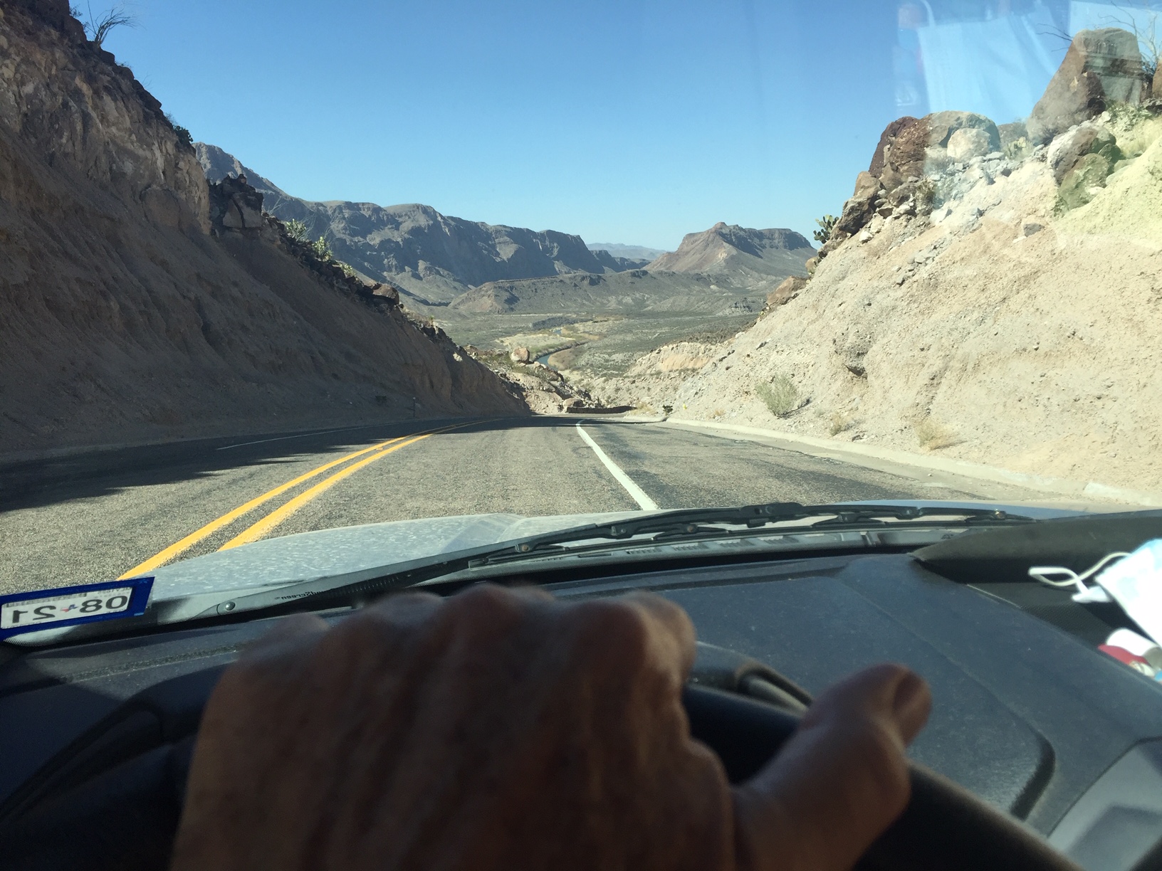
This will be my third trip to BBRSP. If you have read Edward Abbey’s Desert Solitude, then you will understand when I say this reminds me of his description of the old dirt entrance road to Arches National Park. The entrance road is 26 miles of graded dirt, which crosses draws, winds through canyons and is suitable for any reasonable vehicle, but it’s not recommended for large RVs. I hope they never pave this road. 


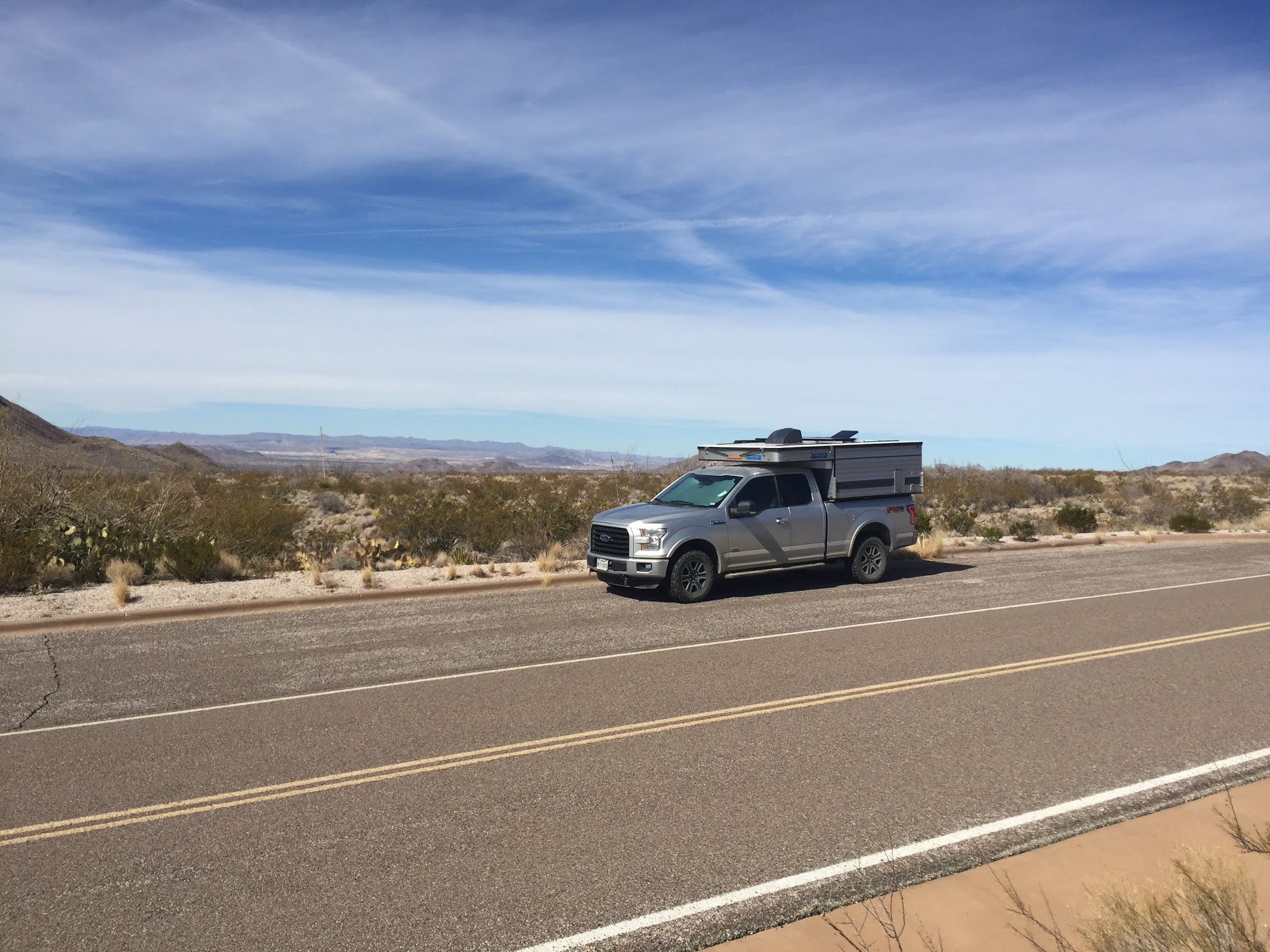
My combination, F150/Enzo, handles the road easily at 30 - 40 mph until I catch up to two very large horse trailers traveling a steady 5-8 mph. I drop back to eat less dust and settle in for a very long drive. I finally reach a scenic pull off, stop for lunch and let them continue their crawl, since there is absolutely no place for them to pull over and let me pass.


By the time I catch them again, they are pulling in to some corrals and I have the road to myself again. I have to check in at the Sauceda Ranger station, which was a private working ranch before it became a state park.


                                                        Sauceda Ranger station


As I stated, the main park road is suitable for most vehicles, but the miles and miles of road leading to campsites and trailheads require at least high clearance and often 4WD. It was a slow day at the ranger station, so I spent some time talking with the Ranger. He told me that the park handles any vehicle mishaps themselves, since wreckers won’t come out. The most common vehicles they rescue are all wheel drive Subarus. He said people believe they can go anywhere. The ranger station has trash, water and SHOWERS !!!!!! The showers are open 22 hours a day. I’ve been doing solar showers etc, which work, but just not the same as the real deal.


My first night is at Los Ojitos, which is only about 1 1/2 miles from the Ranger Station, the last half mile is a rocky 2 track road. I couldn’t hear a man made sound, nor see a man made light in camp. The nearest campsite to me is about 2 miles away but separated by a number of rocky ridges. 


                                             Los Ojitos Campsite


But amazingly I have two Verizon LTE bars on my cellphone, so I thought I’d post. 


Most likely after this, I’ll only be able to post using the wifi at the Ranger station. I have to stop there each time I change sites, so I’ll shower, trash out, refill water and post. I have three nights at Pila Montoya 3 and then two nights at La Posta before I leave the interior of the park and head out to camp near the river.


Scott asked about the front of Enzo being lowered in many photos. Pointing the truck south and dropping the front section of roof gains me about 2 amps of solar gain. My battery bank is two 240 amp-hour, 6 volt batteries, which gives me 120 amp-hours of usable power at 50% depth of discharge (DOD). The panels have kept up, but they also receive a charge from the alternator when driving. I only got down to 70% DOD once when I had 2 cold, cloudy days and didn't drive.


Tight lines and safe travels


Saturday, January 30, 2021

BBNP part 5

 Tuesday, at 11 am I was the last vehicle in the first group going down the mountain when they opened the Chisos basin road. They were paving the road today. After stopping at Panther Junction, I headed north towards Persimmon Gap and my next campsite at Nine Point Draw Primitive Backcountry site. The road to the site is a good gravel road with only one rough stop. The site is not far from the road and I can hear the occasional vehicle, however it has a feeling of complete isolation.


                                             Dog Canyon from Nine Point Draw Camp


                                                        Dog Canyon Entrance


                                                     Moon rise over Dog Canyon 

                                                 Nine Point Draw Camp

After leveling the truck, and popping the top, I made lunch, went for a short walk and then just relaxed. My legs were still a bit tired. But I have a great view of Dog Canyon, which is my next hike. 


Wednesday, I hiked north, 15 minutes, cross-country until I crossed the Dog Canyon trail which runs North to South then followed the trail into Dog Canyon. I really like being able to do hikes from camp. It was a nice level short 4 mile hike which was great to stretch the legs without to much effort. I met a trail crew doing drainage repair work on the desert section of the trail. I considered doing the Devil’s Den hike as well, but instead followed Nine Point Draw out of Dog Canyon, avoiding the normal trail. The draw parallels the trail and is about half way between my camp and the trail. When I thought I was near my camp, I climbed out of the draw and then head south cross country to camp.


Thursday, I left Nine Point Draw campsite and drove to Panther Junction, dumped my trash, refilled water, then headed east to hike the Pine Canyon Trail. The hike is a short 4 mile round trip hike to a 200 ft pour off, but it gains 1000 feet in elevation, most in the last mile. After about 30 minutes,  I met the same trail crew from yesterday, we chatted and then I moved on. Quite the coincidence since I was 40 miles from Dog Canyon and given the number of trails in BBNP.

Last time Nancy & I were here it was a frozen water fall. This time I could hear water trickling, the rocks were damp, but that was it. I had the place to myself, scattered a little of Nancy, had lunch and then about 20 minutes later the trail crew arrived. I packed up and headed out.


                                                        Pine Canyon Pour Off
                                                             Pine Canyon Trail

After the hike I headed west to Paint Gap 1 Primitive campsite for 2 nights, for my last two nights in Big Bend National Park before heading to Big Bend Ranch State Park.


                             Another Awesome Moon rise, this time from Paint Gap 1
                                                       Paint Gap 1 Camp site

Paint Gap 1 is quite a distance off the main park road, on a fairly good dirt road, I can’t hear cars, but the road doesn’t dead end at my site, it continues to two other primitive sites, which are miles further down the road. I ‘m still extremely secluded and have great views of the Chisos Mountains which are to my south, as well as vast expanses of desert. As the sun set I was not only treated to a great sunset, but an incredible moon rise. It seemed close enough to reach out and touch. Its time’s like this I wish I had a real digital SLR camera, rather than just my iPhone. I had to lower the resolution on the attached photos because I had pretty pour connectivity.


This morning I’m heading to Big Bend Ranch State Park. Currently, in a pill off with a full rack of cell bars, who knew technology would expand here.


Tight lines and safe travels


Tuesday, January 26, 2021

BBNP Part 4 1/26/21

First, I’ll answer some questions which have appeared from readers. 


1- The tie down tree is named as such because native peoples tied down a young tree to make a landmark. The tree points towards a reliable source of water. Cattail falls.

2- Mask wearing is mandatory in all indoor places, in fact the little store in Chisos Basin, not only requires masks, but limits 5 people in the store. I had to wait a few minutes to enter. Lots of people mask up as we approach each other to pass on the trail.

3- I have Verizon and yes coverage has greatly improved over the years, albeit not in campgrounds, except the Chisos, because of topography. Best coverage is found when hiking or a few pullouts along the road at either high spots or in the middle of large expansions of desert not surrounded by mountains.

4- Yes, I am very happy Tom Brady is going to the Super Bowl again. My campsite reservations all end on Super Bowl Sunday. I was debating whether or not to continue my road trip, but have decided to go home at least for a day and watch the game. Tom and the Buccaneers will have there work cut off for them. KC is a much better team, but underdogs do win.


I am very grateful this trip, it has been wonderful and very up lifting. I have talked briefly to lots of folks on the trail, at summits and in camp. It has restored my faith in my fellow Americans. There are no politics out here, people are happy, in the moment and joyous. I plan to carry this feeling with me when I leave. I also think I turned a huge corner with my grief and am settling into this solo travel lifestyle. 


I also feel I’ve been very lucky. My luck continued on Sunday. The desert was very foggy after leaving Cottonwood Campground. I fueled the truck in Panther Junction, and headed up the Chisos Basin road about 9:30am. Sunday is the only day the road is totally open without construction. There is a very small parking lot (13 cars) at the trailhead for the Lost Mine Trail, which is about 3/4 of the way up the road. I decided that if I got a parking spot I would do the hike. I approached the parking lot at about 5 MPH, it was full. As I was passing the middle of the lot, I saw the backup lights of a car. I stopped, backed the truck up, they left and I squeezed into a spot.


Lost Mine Trail is 4.8 miles RT with a 1100 ft elevation gain. It would be a good warm up for Emory Peak, which I planned to do on Monday. The trail begins in the woods and then climbs to an open ridge. Many people stopped here, probably due to the exposure and windy conditions, I continued to the final summit and had the place to myself for 45 minutes. I had lunch, and then headed back down.


                                             From the summit of the Lost Mine Trail


I arrived at my campsite and was a bit confused until the host arrived. My parking spot was on one side of the campground road, while my picnic table was on the other. I found two large 4 inch thick, flat rocks, shifted into 4WL and drove up on the rocks and was perfectly level. Although I had quite the step up to Enzo's first step. The walk back and forth added some more training steps and the view from the picnic table was incredible.


                                                                               My site

                                                               My view from the picnic table 

Monday, I hit the trail a 8am heading for Emory Peak. Leaving from the campground adds 0.4 miles each way, but it also met I would be able to just walk back, and relax without having to setup camp. What the hell, Emory Peak is a 5.5 mile hike one way from the trailhead, in for a penny in, for a pound. I was another beautiful day. Morning temp was about 45 degrees and the high was predicted to be low 60s. Perfect for a big hike. It took 3 hours and 15 minutes to summit. I passed a number of folks along the way, most were my age or older. I declared it to be Medicare Monday. Later, some younger folks passed me. The last 150 ft or so is a vertical scramble, I rated it a 5.0 climb. There are two peaks, both have antennas and solar panels, probably radio repeaters and not cell towers. I stayed on top for about an hour and a half, including both summits and the pre summit area below the vertical summit scramble.

                                              Early morning on the lower trail to Emory Peak
                                                   The East Summit from the West Summit 
                                                                      East Summit Selfie
                                                                     The West summit

                                                            The West Summit, looking east

I got back to camp at 3:45pm, pretty tired. The last 3 miles of the return trip really kicked my ass, 11.3 miles was the longest hike I have done since Nancy was diagnosed. But all I had to do was wash up, grab a beer, and relax. I had planned to cook a nice steak dinner, but opted for leftovers, just to tired. Tuesday was a rest day and I move to my first backcountry campsite.

Its 9am as I finish typing this post, the Chisos Road is closed until 11am, I don't have to leave my campsite until noon, so I'm in no hurry. My legs are very tired but not sore, so I'm happy about that. I have no clue as to if I will have coverage in the backcountry site. 

Tight Lines and safe travels

Sunday, January 24, 2021

BBNP part 3

 1.24.21

                                   Friday’s hike to Cattails Falls, photos as promised


                                            The Tie down tree, and one of Nancy's favorite spots 


                                                          Cattails Falls Trail


                                                           Cattails Falls Entrance


                                                                 Cattails Falls


                                                        Tufts Canyon Overlook


                                                                Tufts Canyon


Saturday, I hiked into Burro Mesa Pour Off ( 2 miles RT) and Burro Mesa Spring, (4.8 RT). The Pour Off trail probably is one of the best 1 mile hikes I done. I had it all to myself until I was just about back to the truck, when I ran into a couple from Bow, NH, go figure. We chatted and then moved on. 


                                                         Burro Mesa Pour Off Trail


                                                     Burro Mesa Pour Off Entrance


                                                           Burro Mesa Pour Off


                                                   Looking Up Burro Mesa Pour Off


I love the “miles to empty feature” on the F150, since I only get 14 MPG and the closest gas station is in Panther Junction, 35 miles from Cottonwood Campground, it’s reassuring to see that I had 122 miles remaining as I made the turn from Burro Mesa and headed back to the campground. I don’t need another vehicle incident on this trip.


This is where I had a full rack of Verizon bars and posted my previous blog post


Saturday night was my last night at Cottonwood and I was rewarded with a pretty spectacular sunset.


I moved to Chisos Basin today, and have great cell coverage, so I'll post my Chisos adventure tomorrow.


tight lines and Travel Safe 


Saturday, January 23, 2021

BBNP Part 2


Alls well that ends well. 


The wrecker dropped the truck at the Ford dealer, in Ft. Stockton, Wednesday, at 12:45pm, and then at 5:15pm I was headed south back to Big Bend National Park. As I suspected it was the engine temperature sensor, a $26 part. Diagnosis, labor and parts came to $101. I was very thankful and grateful that they were not only able to get the truck into the service bay on the same day, but that they had the part in stock. It was 161 miles, and 3 hours back to Cottonwood Campground and I arrived at 8:15 pm. Poured myself a bourbon, cooked a couple of pan fried burritos and my little world was back to normal. 


Thursday morning, I woke to a gentle desert rain, and a fairly deserted campground. The empty sites all had tags which were valid until 1/22, but I guess the rain drove people out. I actually enjoy the rare desert rain. The desert takes on a sweet smell, and animals seem to become more active. I heard coyotes, an owl, numerous woodpeckers and even saw a lone white horse. I decided that I had enough driving on Wednesday, so after the rain stopped I drove the 8 miles to Santa Elena Canyon. It was an absolute mud hole, so I took it as an omen that today was going to be a day of relaxation and drove back to camp.


Friday, was a beautiful day, full sun which warmed the desert to the low 70s. I drove about 25 miles to the trailhead for Oak Spring. The gravel road was blocked about 500 yards in, so hiking the rest of the road added about 1.25 miles each way, but I was the only person. I hiked to the tie down tree, spread a little bit of Nancy, we had been here years ago, then continued to Cattail Falls, which is sort of a hidden little hike and one of the water sources for the park. I hung out at the falls for a while and then headed back. After 1o minutes I began to meet others hiking in. Total distance 4.5 miles. On the drive back to camp, I did the short 3/4 mile hike into Tuff Canyon and then continue through the slot canyon until I reach a short cliff blocking further progress, at least without someone else to spot me. Back to camp for a beer, steak, salad and leftover fried rice. A perfect day!


Just a reminder, there is very limited cell coverage and wifi exists at 3 spots in the park, nothing at Cottonwood Campground. I really appreciate the texts, emails, and comments, but I can’t respond in a timely manner. I have been writing my blog offline, then posting when I get a connection.


I’m sitting in a pull off near the mule ears, about ten miles from the campground, after hiking around the Burro Mesa area. I saw that I had a cell signal so stopped. No photos this time, I’m moving to the Chisos Basin on Sunday, and should have wifi and cell coverage there, maybe. Fingers crossed.

Wednesday, January 20, 2021

BBNP part 1 The Universe laughs

 Saturday, 1/16/21, The temperatures at the Ranch have recently been in the low 20s, so I decided to fill Enzo’s water in the morning, also because my motorhome furnace is over 16 years old, has never needed any repairs, I decided to play it safe and winterize the Moho. I  set the furnace at 45 degrees, had an early lunch, brought in the slides and hit the road just after noon. I made a quick stop at the grocery store to pick up some fresh produce. I planned a very short driving day, so I spent the night at Sunset Reef Campground, which is a free campground just south of Whites City, NM. The campground was previously a drill site. Rather than rehabilitate it back to the original desert, a number of private companies and government agencies joined forces to create an eleven site campground, complete with a SST pit toilet and covered picnic tables. I hope this idea gains traction and more abandoned drill sites end up like this. 


Sunday, I hit the road at 6am, and drove through oil country. This part of the permian basin is oil and gas mecca. Both sides of the road were dotted with drill rigs, pump jacks, storage tanks, processing plants, pumping stations, pipe lines and man camps. Travel was slow due to the numerous road construction one lane road closures. As I headed further south, the road construction ceased, the evidence of petroleum exploration decreased, creosote bushes began to dominate the landscape and the mountains of west Texas came into view. 


There is something that is relaxing about the desert mountains of West Texas. The roads run through the flat basins, and one can see for miles, since Creosote bushes only grow to 3-4 feet in height there is nothing to block your view.


I past through the North entrance station of Big Bend National Park around 1pm, and reached Cottonwood Campground around 2:15pm. The park road to the campground circles around the southern side of the Chisos Mountains and offers some incredible views of the high peaks, as well as panoramic views further west and south. The Big Bend National Park is mostly undeveloped, with only a few paved roads. Its vast expanse, larger than the state of Rhode Island, can’t be appreciated unless you spend a week or more here.


                                                         The Mule Ears

                                                Cottonwood Campground


I settled into my nice level site, with unshaded, southern exposure, a picnic table, large metal bear box, of course here it’s really a Javelina box. The reservation site listed Cottonwood Campground as a dry camp, so I was very surprised to see non-potable water faucets space along the campground road as well as a free reverse osmosis water fill station in the campground. 


                                         The Rio Grande River with Mexico on the left


The campground is on the banks on the Rio Grande River. The river is only about 30 feet wide and a couple of feet deep. Mexico is literally a stone’s throw from the campground, no fence, not even a sign, just wilderness.


Monday I headed out after breakfast to hike the Chimneys Trail. It’s basically just an easy walk thought the desert. The trail head is only about 12 miles from camp and after driving 312 miles the previous day, I thought it would be nice not to spend much time driving.


About 2.4 miles from the trail head, the trail reaches the Chimneys, rock pillars which rise from the flat landscape. There are some petroglyphs and ancient rock shelters hidden among them. It only took me an hour to reach the Chimneys, so I decided to continue on the trail for another mile, before having lunch and turning around.


It was only 2 o’clock when I got back to the truck, so I thought I might stop at one of the roadside exhibits on the way back to camp and go for a short desert stroll. The Universe had other plans for me. After a few miles of driving the “Coolant High Temperature” message and icon appeared on my dashboard and the truck went in to “safe driving mode”. I pulled over, check the coolant level, which was fine, read the manual and followed the instructions. Which said to let it idle for a few minutes, if it doesn’t cool down, shut off the engine and let it cool. An hour later, when I started the engine the message was there and the engine was still in safe mode. It said I could drive a short distance. I was four miles from the campground so off I went. I limped along at 10 MPH and made it to camp. 


The next morning, Tuesday, after it sat all night in 50 degree temperatures, and was cold to the touch, the message was still there and the engine was still in safe mode. There is zero cell phone coverage in the campground, no pay phones, but lucky for me the campground host had installed a hard phone line at her site. She let me use her phone to call roadside assistance. I spent an hour on the phone with an agent. She could find Cottonwood Campground on her map program, but her system would not allow here to input it as a location, then the call dropped. By then the host provided me a list of Ford dealers and Wreckers. The nearest Ford dealer is Fort Stockton, TX, 150 miles. 3 hours and $1025 tow away. I scheduled a wrecker to arrive between 9 and 10 am today, Wednesday 1/20/21.  


So here I sit, drinking coffee and waiting for the wrecker, I’ll post this when I get to the Dealer. In the mean time, I’m very grateful for Karen the Campground host, her phone, and the fact that I was able to limp back to camp at 10 mph, rather than be stuck on the side of the road. I’m also extremely grateful, that I wasn’t in a backcountry campsite in Big Bend Ranch State Park, 30 miles from a paved road. It could have been much worse.


More as it happens, stay tuned.

Monday, January 11, 2021

Solo Safety in the back country

 In a previous post I spoke about learning to travel in my motorhome alone and how I needed to do a little more planning as to overnight stops. Gone are the days that I can have my co-pilot look for an overnight stop an hour or so before I want to stop.

In a similar vain, I needed to examine the amount of solo hiking and fishing I do and what steps I can take to minimize risks. I have been thinking about this for a while. A couple of incidents in the last 8 months have made me aware that I need to do something. During the summer when I was fly fishing with Sonia up on the Grand Mesa, I walked across what I though was a little mud. It turned out to be quick mud and within minutes I was stuck up to mid thigh with both legs. Luckily Sonia and a fly fisherman were able to toss me various logs and about 45 minutes later I was able to get unstuck. Sonia had a Spot X, a satellite messenger device, which we didn’t need but would have been useful had I not been able to get out. But since there were two of us, she could have just driven my truck for help. 


But if I was fishing alone, it might have been a long cold night if another fisher person wasn’t nearby.


During one of my recent solo hikes in the Lincoln National Forest, I came upon a family of Javelinas, that day I had not seen another person the entire time I was hiking. The Javelinas were a good distance away and ran away from me. It did get me thinking that had I come across them suddenly and much closer, dad Javelina, may not have been very happy and my understanding is that they can be dangerous.


Yes, there is a school of thought that says I shouldn’t do this stuff alone, but that isn’t a reality for me, if I want to do the things I enjoy. I always carry my cellphone, since it is also my camera, but I don’t always have cell coverage. 


I have been weighing the pros and cons of various satellite messenger devices vs Personal Locator Beacons, (PLB). I finally settled on a PLB, there is no subscription fee and they all use the COSPAS/SARSAT satellite system rather than a private propriety satellite system.


In preparation fro my upcoming Big Bend trip I purchased a ACR ResQlink 400 PLB. Basically it is a backcountry SOS device for any life threatening emergency when you don’t have cell phone service. You deploy a very small antenna, which covers the emergency activation button, then press and hold the activation button for 2 seconds. It will then send your GPS coordinates and an emergency beacon for 24 hours via the COSPAS/SARSAT satellite system to NOAA, which then contacts the local search and rescue. It also has an infrared strobe light to help SAR locate you. 


                                                 The PLB is pretty small


Additionally, I wear MedicAlert dog tag and subscribe to their service. The dog tag has a toll free number and my ID number. Emergency personnel can call the number and speak with someone who has access to my medical information if I am unconscious. The demographic and medical information is easily updated by me online.


Of course, a rescue in the backcountry is not like dialing 911 at home, so I might have to hang around a long time and therefore always have extra clothing layers and an emergency survival shelter in my pack as well as the other essentials. Worse case scenario, SAR would know what to do with the body if the rescue turned into a recovery. That's for my good buddy Scott, since I know he's thinking it about now. 


I would encourage anywhere that ventures into the back country alone to consider a PLB or a satellite messenger device. 


I am leaving Saturday to begin my next road trip. I’ll spend 2 weeks in Big Bend National Park and 8 days in Big Bend Ranch State park. I will have very limited cell service if any, and there are only three locations with WiFi in BBNP. BBNP is larger than the state of RI, so I won’t be passing by the WiFi spots very often. But I may do an blog update while I’m there.


Tight lines and safe travels


Alaska, the final installment

  Saturday, 7/6/2024 My trip was winding down and after a nice morning with Michelle and her dad, I headed north back to Anchorage to visit...